For nearly six months of the year, the Mackenzie Delta on the Northwest coast of Canada is barely recognisable as a river delta. It is blanketed by an icy mantle that merges its islands and waterways with the frozen coastal plain. Biting winds scour this flat Arctic wilderness, which for several weeks in the depths of winter is cloaked in darkness, with no sunrise.

At this time, the only light comes from the eerie, ever-present moon and the spectacular northern lights, or aurora borealis - sky-filling curtains and streamers of mainly green and crimson light. The Inuit thought the northern lights were reflections from the dance fires of ghosts.

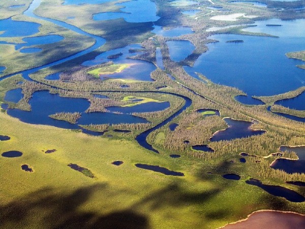
Spring arrives dramatically in the Mackenzie Delta. As the long winter draws to a close, isolated communities of delta dwellers wait eagerly for the welcome crash and splinter of melting ice. As huge ice blocks break off and hurtle seawards, buffeting the river banks on their way, life on the delta begins anew. Within hours, the noisy thaw reveals an extensive fan-shaped network of channels and lakes separated by countless small islands.
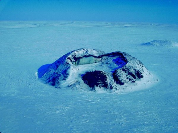
The full extent of the Delta's complex tracery - which stretches north about 100 miles (160km) to the Beaufort Sea and spans 50 miles (80km) of the coast - can be seen only from the air. The Land is low-lying, and most of the islands barely clear the water. Here and there, as if to emphasise its flatness, the landscape is punctuated by conical hillocks known as pingos, from an Inuit word for the mound. Each mound has a frozen mass of ice at its core. There are more than 1000 pingos in the Mackenzie Delta - the greatest concentration of them anywhere in the world.

In summer, the Delta is constantly being shaped and reshaped by the force of its powerful, mud-laden waters, which alternately erode and build up its banks, season after season. In the Americas, only the Amazon and the Mississippi discharge a greater flow of water than the Mackenzie, which drains three lakes - the Athabasca, the Great Beat, and the Great Slave. The mainstream is from the Great Slave Lake, which is about the size of Alabama.

It is North America's deepest lake, some 2015ft (614m) deep. Even though the Mackenzie flows for only about 1100 miles (180km) from the lake to the sea, its basin covers an area that is as big as France, Germany, Italy, Spain and Portugal combined, for it has several direct tributaries as well as several indirect ones that flow into the lakes.
A Scot named Alexander Mackenzie opened up the river and its delta to fur trappers in the late 18th century. Mackenzie, who was employed by the North-west fur Company, was chosen by them to explore the north-west in June 1789. He set out from Fort Chipewyan, on Lake Athabasca, with a party that included native Americans and Canadian voyageurs (boatmen). They travelled in birch-bark canoes.
Mackenzie hoped to discover a route leading westwards to the Pacific and was delighted when he found a river flowing westwards from the Great Slave Lake. But as he continued navigating its churning waters, he realised that it turned northwards towards the Arctic Ocean instead of continuing to the Pacific. Now the river is named after him. However, Mackenzie himself called it the "River of Disappointment".


 Click it and Unblock the Notifications


