


 Click it and Unblock the Notifications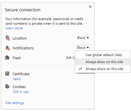




The India Meteorological Department (IMD) issued a heavy rain alert for Surat today, July 21. Intense thunderstorm spells are expected to persist through the entire day. Residents must anticipate significant waterlogging in low-lying zones and possible commute delays. Civic authorities advise extreme caution due to the monsoon surge.
Persistent rain could cause flash floods and rising water levels across South Gujarat. Recent downpours have already impacted flight schedules and local train movements. The Surat Municipal Corporation (SMC) is actively using pumps in vulnerable city spots. Frequent commuters should monitor live traffic maps before starting their journeys today.

Managing Travel with a Heavy Rain Alert in Surat
The India Meteorological Department (IMD) has highlighted Navsari, Valsad, and Dang as high-risk zones. These districts might face isolated extremely heavy rainfall during the late afternoon hours. Riverbank areas and older urban clusters in Surat face higher flooding risks. Avoid parking vehicles near large trees or old buildings during the storm.
Waterlogging Risks and Safety Measures in South Gujarat
Severe waterlogging is likely near Sahara Darwaja and several underpasses across the city. Travelers should check the Tapi river discharge levels through the official civic portal. Utilize the IMD nowcast service to track rain clouds in your immediate vicinity. Local helplines are fully operational to help people stuck in heavy traffic.
| Location | Alert Level | Impact Focus |
|---|---|---|
| Surat City | High | Underpasses and Traffic |
| Navsari | Very High | Low-lying areas |
| Valsad | Very High | Riverside Safety |
Recent data shows that coastal districts are most vulnerable to these sudden cloud movements. Farmers in the hinterlands should protect livestock from potential lightning strikes and runoff. Local schools may adjust timings if rainfall intensity increases during the morning. Stay updated with the latest alerts from the district disaster management office.
Regional weather patterns suggest these heavy spells will stay for two more days. Ensure you have essential items and keep electronic devices fully charged for emergencies. Checking official news channels will provide the latest road closure updates. Staying informed ensures safety and helps in better planning for outdoor activities.