


 Click it and Unblock the Notifications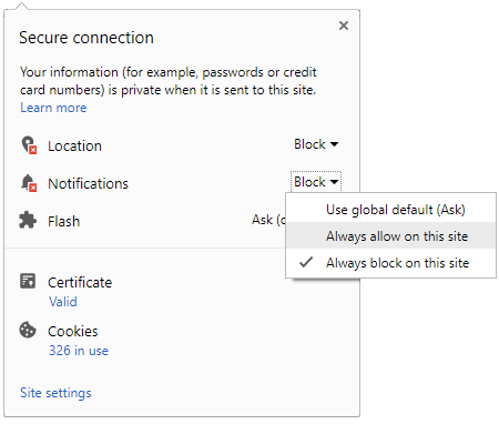




Today, Tuesday, September 15, Gujarat faces a fresh rain alert. The India Meteorological Department (IMD) warns of heavy showers over Saurashtra and Kutch. Flash‑flood risk persists till 11:30 am, focused on coastal and low‑lying belts. Districts on watch are Rajkot, Jamnagar, Porbandar, Junagadh, Morbi, Devbhumi Dwarka and Kutch. Alerts are mostly yellow, with gusts of 30–50 kmph possible.
Met Centre Ahmedabad’s day‑three forecast lists isolated heavy rain in these districts. Thunderstorms with lightning may accompany showers, especially near the coast. Jamnagar’s city forecast also flags heavy rainfall for today. Expect short, intense bursts that can overwhelm drains during commutes.

District-wise IMD alerts for Saurashtra–Kutch today
| District | Alert colour | Likely intensity today | Flash‑flood risk window |
|---|---|---|---|
| Rajkot | Yellow | Heavy rain at isolated places | Till 11:30 am |
| Jamnagar | Yellow | Heavy rain at isolated places | Till 11:30 am |
| Porbandar | Yellow | Heavy rain at isolated places | Till 11:30 am |
| Junagadh | Yellow | Heavy rain at isolated places | Till 11:30 am |
| Morbi | Yellow | Heavy rain at isolated places | Till 11:30 am |
| Devbhumi Dwarka | Yellow | Heavy rain at isolated places | Till 11:30 am |
| Kutch | Yellow | Heavy rain at isolated places | Till 11:30 am |
Travel impact and safety tips during Gujarat rain alert
Build 30–60 minute buffers for flights, trains and key highways. Avoid underpasses, service lanes and low‑lying stretches that flood quickly. Coastal winds may roughen the sea and swell tide‑affected creeks. Keep devices charged and park on higher ground. For assistance, State Control Room is 1070, district control is 1077, and 112 works nationwide.
What to track now: IMD nowcasts, radar, next 48 hours
Keep IMD’s Nowcast dashboard open for one to three hour warnings. Watch Bhuj radar loops for approaching bands and mesoscale bursts. If thunder roars, move indoors and avoid trees or metal. Through Wednesday, showers begin to step down, with lighter, patchier rain expected on Thursday.
The highest immediate risk extends through late morning today. Localised flooding can still follow any evening squall, especially near creeks and tide‑influenced roads. Carry drinking water, a flashlight and ID. If routes flood, turn back early and rely on official advisories before planning longer trips.