


 Click it and Unblock the Notifications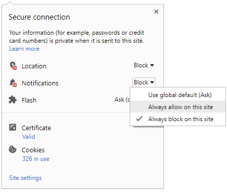




The India Meteorological Department (IMD) issued fresh weather warnings for several regions today. Heavy rainfall and severe thunderstorms are expected across southern and central belts. Kerala, coastal Karnataka, Odisha, and Chhattisgarh remain under active orange watch. Commuters should expect disrupted travel schedules and potential waterlogging in urban hotspots.
Weather forecasters are monitoring real-time changes through strict three-hour nowcast updates. Key tracking slots include 08:30, 11:30, 14:30, and 17:30 IST. Strong surface winds reaching up to sixty kilometers per hour are expected. Sudden lightning bursts pose severe safety risks during peak afternoon travel hours. Travelers must track live updates before heading outside.

IMD Rain and Thunderstorm Alerts for Southern and Central India
Subtropical monsoon systems are driving intense rainfall over coastal Karnataka and Kerala. Meanwhile, Chhattisgarh and Odisha face prolonged downpours caused by active low-pressure troughs. Heavy precipitation increases flash flood hazards in low-lying residential regions. Local administrations urge residents to stay indoors during heavy spells. Plan transit routes carefully to avoid sudden road blockages.
| Region | Warning Level | Key Impact |
|---|---|---|
| Kerala and Coastal Karnataka | Orange Alert | Flash floods and coastal wind gusts |
| Odisha and Chhattisgarh | Orange Alert | Urban waterlogging and lightning risk |
Managing Commute Impact and Self Verification
Air travel and rail operations may experience delays near coastal and central airport hubs. Urban commuters face waterlogged roads, slow traffic, and potential public transport suspensions. Passengers should consult airline advisories before leaving for the airport. Traffic police departments continuously publish live route updates online to assist commuters.
Checking verified weather sources helps citizens avoid hazardous road conditions and sudden storms. The State Disaster Management Authority (SDMA) issues regular location-based safety bulletins. People can monitor live Doppler radar maps on official meteorological portals. Cross-referencing traffic police alerts ensures smoother and safer daily travel decisions.
Staying informed remains vital as wet weather patterns persist across key southern and central corridors. Commuters and travelers should keep emergency contact numbers accessible throughout the day. Adhering to official warnings reduces transit risks during unexpected thunderstorm activity.